The Watermills of the River Lostock
The river Lostock is a
small river, barely more than a stream, that winds for eight miles from its
source in the hills near Wheelton to a junction with the river Yarrow near Croston.
It is an unprepossessing feature in the landscape, sometimes hemmed in
by urban development and flood prevention walls. In the 18th and
early 19th centuries, by contrast, it was the catalyst for the growth of
the cotton textile industry in the South Ribble area. In this article I will
consider the role of waterpower in the development of the cotton
industry in this part of Lancashire. I will also look at the ways that mill builders harnessed the river Lostock to power the corn and cotton mills that developed along its banks.
Well, some of them
anyway. The first edition Ordnance Survey map of the 1840s shows no fewer than
ten water-powered mills (eight cotton factories and two corn mills ) along the Lostock’s eight mile course. I won’t try to
discuss them all in depth, but will concentrate on those mills I covered in
my article on the cotton industry in the Whittle-le-Woods area – with one (corn mill) addition.
It may be wondered how
such a small river as the Lostock could have the capacity to power so many
factories. However, the power requirements of early cotton and corn mills were modest, most
needing little more than 10 – 20 horsepower. A fast-flowing stream could
generate up to 400 horsepower, quite sufficient to power a number of mills. The
Lostock was not unique in having several factories along its course. However,
it was possible for streams to “run out of water” and disputes sometimes occurred
when firms accused those upstream of “hogging” water, depriving them of
necessary power.
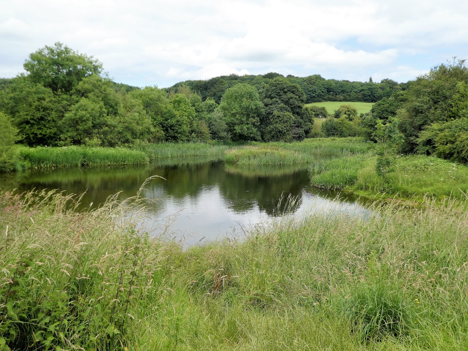
 |
| The river Lostock is little more than a stream, but had more than enough power for the ten mills sited on its eight-mile course |
Water power was widely
used in the early cotton industry in Lancashire, leading to early mills
being established in rural areas where suitable streams (and the land to build
factories) were available. The very first cotton mills, however, derived their horsepower
literally from horses. Richard Arkwright’s very first spinning mill, set up in a
converted house in Nottingham in 1769, was powered by a horse capstan and horses
provided power for factories up to the end of the 18th century. The positioning of the mills in the south Ribble area next to the Lostock
indicates however that they were water-powered from the outset. The full list
of mills and factories along the Lostock downstream from its source is as follows, with those discussed in
this article highlighted in bold:
1.
Carding
Engine, Wheelton (probably connected with Sitch spinning mill, Higher
Wheelton).
2. Denham
Springs Print Works, Brindle.
3. Lowe
Mill Print Works, Whittle-le-Woods.
4. Kem
Spinning Mill, Whittle-le-Woods.
5. Lower
Kem Print Works, Clayton-le-Woods.
6. Clayton
Corn Mill, Clayton-le-Woods.
7. Clayton Print Works, Bamber Bridge
(later Cuerden spinning mill).
8. Lostock Hall spinning mill (probably a
former corn mill).
9. Walton spinning mill, Lostock Hall
(later Cuerden Green and Lostock spinning mills).
10. Farington corn mill.
Waterwheels
and Water Power
The components of a
water power system are straightforward. Water is directed from a river or
stream at a weir into a channel, known variously as a mill-race, head-race or
leat. The channel leads to a reservoir (called a mill pond or, in the
cotton-manufacturing areas, a lodge), where it is stored until needed, the flow
being regulated by sluices. Another channel directs the water onto the
waterwheel, the flow causing it to rotate. The resulting motion is converted, by a
network of cogs and gears, into power for the mill’s machinery. Meanwhile, the
water leaving the wheel is returned to the river downstream from the mill, along
another channel, named the tailrace. It is a technology that has been used
worldwide since prehistoric times.
The actual design of individual
water-power systems varies, depending on the nature of the water source, the
topography of the land on which the mill is sited and the mill’s power needs. The
key issue is the type of waterwheel to be employed. Traditionally, waterwheels were “undershot”, that is, the water flowed beneath the wheel, which turned
through the water striking paddles around its edge. Experiments by the celebrated
engineer John Smeaton in the 1750s demonstrated that this design of wheel was
very inefficient, using little more than 20% of the potential energy of a
river. Much better was the “overshot” wheel, which was powered by water from
above (directed along a channel called a “pentrough”), the wheel being turned
by water falling into buckets sited around its circumference. The weight of the
water forced the full buckets downwards, causing the wheel to rotate. The
disadvantage of an overshot wheel, however, was that it required a considerable
“fall” – the difference between the height of the pentrough and the river
itself. This meant that overshot wheels could only be used in areas where the
river was flowing down a steep gradient, or where a very long headrace could be
constructed.
A compromise design was
the “breastshot” wheel, in which the water was directed onto the wheel near
its centre line, again falling into buckets. This retained much of the efficiency of the overshot
wheel, while requiring less “fall”, thereby becoming more practical to
construct. The majority of waterwheels in cotton mills were of the breastshot
design. For a diagrammatic representation of the different types of waterwheel,
see here.
The design of the
waterwheels themselves improved during the 19th century. As power
needs increased, wheels became bigger and heavier. This led to the development
of the “suspension wheel”, which had spokes like a bicycle wheel, reducing its weight. Such wheels turned very slowly, while mill machinery
needed fast rotation, so suspension wheels had a small wheel on a cog system
inside their circumference. Thismuch increased the revolutions passed on to the
network of rods and straps that powered the actual machinery. A working example
of a cotton mill powered by a suspension waterwheel is Quarry Bank Mill,
Styal, owned by the National Trust.Towards the end of the 19th
century, surviving waterwheels were often replaced by more efficient turbines.
Water
Power and Steam Power
Steam engines began to
be introduced into cotton mills in the 1780s, but they never completely
replaced water power in the cotton industry. Early steam engines were costlier than waterwheels, were inefficient
and unreliable and sometimes produced a jerky motion, leading to thread
breakages in spinning mills. The first steam engines in cotton mills were actually used to pump water uphill to reservoirs, from where it was released to power waterwheels. Up until at least the 1820s, water powered mills
on good streams were often as efficient and effective as those powered by
steam.
The big advantage of
steam, of course, was that it enabled mills to be established in towns, away
from the streams and rivers essential for waterwheels. In urban areas,
recruitment of workers was easier, transport links were better and economies of
scale easier to achieve. The great urban centres that grew up in Lancashire were
the direct consequence of steam power. However, in rural areas, such as South
Ribble, water power continued to be the prime power source for mills until at
least the 1840s. Many water-powered mills did however install steam engines as
supplementary power sources, for use in times of drought or severe frost, or to
meet raised demand. As the century went on, rising power demands, improved
steam engine efficiency and reductions in the price of coal led to steam
becoming dominant throughout the cotton industry. By the end of the 19th
century, it is likely that all the surviving mills along the Lostock were steam
powered. However in some isolated parts of North-West England, such as at Quarry Bank Mill, water
power continued to be used up to and beyond the introduction of electric
motors in the early 20th century.
The
Watermills of the River Lostock
We will illustrate our
discussion of water power in the cotton industry by looking at how the mills in
the Whittle-le-Woods area used the water of the Lostock to provide power. I do
not have access to specific plans or illustrations of the individual mills when
they were water-powered, so the following descriptions are derived from
ordnance survey and tithe apportionment maps drawn up in the 1840s. I do not
know for sure what type of wheel any of the cotton mills used, but based on the
discussion above and the topography of the area, I will assume that they were
breastshot (as we will see below, Clayton corn mill may have used an overshot wheel). We will follow the Lostock downstream.
Denham
Springs Print Works: This
was probably the earliest cotton factory in the area, opening in 1783. It was
on a cramped site, between the Lostock and the steep and wooded Denham Hill.
Considerable earthworks seem to have been necessary, including
apparently channelling the Lostock itself into a course adjacent to the lodge.
The lodge is built up from the river and two weirs direct
water into it. The (presumably) breatshot wheel was sited in the centre of a building
that butted onto the lodge and the tailrace was culverted under the site. By
the 1840s, the waterwheel was supplemented by a steam engine, whose chimney
still stands.
 |
| The lodge at Denham Springs Print Works is adjacent to the works itself. The river Lostock has apparently been diverted and straightened to allow the lodge to be constructed |
 | ||
| The ruins of Denham Springs Mill are on private land but the splendid weir that directed water from the Lostock into the lodge can be seen from Copthurst Lane |
 |
| A steam engine was added to Denham Springs mill early in the 19th century, to provide extra power when needed. Its chimney is the only one remaining in the area |
The works closed in the
1860s and is now a ruin. It is on private land and not readily accessible, though
the lodge still exists, along with its sturdy weirs. The outflow from the
tailrace can also be seen a little downstream.
Lowe
Mill Print Works: This
works was unusual in possessing two head races or leats, named on the 1840s ordnance
survey map as old and new mill races, leading originally to two lodges. The likely explanation is that the works were probably built on the site of a former corn mill and the “old” mill race
powered that mill. The print works had greater power needs,
necessitating the construction of a larger lodge, served by the “new” mill
race. The 1840s maps show the two lodges sited adjacent to each other, but at some
point they were merged into one. By the 1840s a steam engine was reinforcing
the waterwheel and over the years the works were expanded and eventually were fully converted to steam power. The two mill races can still be seen and
the lodge is an attractive area for anglers and walkers.
 |
| Lowe Mill Print Works in the 1840s, with the old mill race to the right of the diagram and the new mill race parallel to it. The old mill race feeds a small lodge that may have powered the corn mill that was originally on the site. Later in the 19th century the two lodges were combined, but both mill races can still be seen |
 |
| The lodge at Low Mill is a combination of two smaller lodges. It is now an attractive haven for anglers and walkers |
 |
| The river Lostock (to the left of the picture) flows next to the lodge at Low Mill (to the right). The difference in height between the river and the lodge can be seen; this produces the "fall" that provides the power to turn the waterwheel |
Kem
Spinning Mill: It is
unclear when this mill was opened, but it was originally water-powered and may
have retained at least some water power until its closure in the 1880s. A weir at a bend on
the Lostock fed water directly into a lodge next to the river, from where a
long channel took it to a wheel sited in the centre of the main mill building,
The tailrace, as at Denham Springs and Lowe Mills was culverted under the
factory site. In the 1850s, a weaving shed was added to the complex and
possibly at the same time a steam engine was installed. It seems likely that
the weaving shed was steam powered from the outset, but whether the spinning
mill also utilised steam in addition to, or instead of water is not clear.
After the spinning mill closed, it was demolished and its lodge and related
water courses were filled in. All that now remains is the remnants of the weir
and a blocked off sluice.
 |
| At Kem spinning mill the lodge was next to the river, with a long leat (or headrace) leading from it to the mill. The weaving shed was built next to the spinning mill in the early 1850s but was probably never water powered |
 |
| After its closure in the 1880s, Kem spinning mill was demolished and its watercourses filled in. All that can be seen today is the remains of the weir on the Lostock that led to the lodge and a blocked off sluice (best viewed from the far end of the football pitch on Kem Mill Lane). |
Lower
Kem Print Works: This
factory was opened in 1784 and may also have taken the site of a former corn
mill. A longish headrace led to a sizeable lodge in the picturesque Lostock
valley. Unusually, the 1840s ordnance survey map shows the actual site of the
waterwheel, on the edge of a building at the far end of the lodge. This
suggests that the wheel was on the outside of the building. Like Lowe Mill, Lower Kem
Mill was rebuilt and expanded during the 19th century and a steam
engine installed, although it was fully water-powered until at least the 1840s.
The current restored ruins reflect the appearance of the mill in the late 19th
century and the site of the original waterwheel is unrestored and overgrown.
 |
| The exact position of the waterwheel at Lower Kem print works is marked on the 1840s ordnance survey map, suggesting that it was on the outside of the building. |
 |
| The headrace (leat) at Lower Kem print works passed under this low bridge, that led to the mill owner's dwelling, Whinfield House |
 |
| The lodge at Lower Kem mill has been restored to make an attractive feature in Cuerden Valley Park |
Clayton
Corn Mill: We have
seen that two of the cotton factories in the area were sited on former corn
mills and may have partly used their existing water power systems. While agriculture in
the area was primarily pastoral, there was (and still is) some arable farming, requiring corn mills to produce flour from the local crop.
The 1840s tithe apportionment survey suggests that 20% of farmland in
Whittle-le-Woods and 15% in Clayton-le-Woods was arable. By this time, however,
the only corn mill in the area was at Clayton town, a little community off
Lancaster Lane, now abandoned and demolished and part of Cuerden Valley Park. The miller in
the 1840s was Thomas Blackburn and later his son Henry took up the reins. The
mill had closed and been demolished by the 1890s, but remnants can still be
seen. The course of the long headrace can be traced (its length suggesting that
the wheel may have been overshot) and a structure stands next to the main path
through the park that looks very much like the wheelhouse. From here, the
course of the tailrace may be traced.
 |
| The leat at Clayton corn mill is relatively long, suggesting that its wheel may have been overshot (a long headrace allowed for a greater "fall") |
 |
| The long headrace that led to Clayton corn mill can be seen below the path that leads through Cuerden Valley Park. |
 |
| Hidden in undergrowth beside the path near to Lancaster Lane, this may well be the remains of the wheelhouse at Clayton corn mill |
Conclusion
The river Lostock was
exploited for water power for centuries, firstly to drive corn mills and later
(and sometimes on the same sites) for cotton textile factories. The early
cotton industry in the Lostock valley relied on water power and the advent of
steam did not reduce its importance for many years. Eventually, however, steam
power (and later still electricity) became dominant and the mills built in the
second half of the 19th century were steam powered from the outset.
Now all those mills have gone, but the Lostock remains, winding slowly through
the landscape as it has done since the end of the Ice Age, thousands of years
ago.
Sources Used
Tithe maps
available at Lancashire Archive, Preston.
Historic
Ordnance Survey maps available at Old Maps
Directory of Cotton Mills in South Ribble
Chapman S (1987) The cotton industry in the industrial revolution. London: Macmillan
Graham J (1846) Chemistry of Calico Printing 1790-1835 and History of Printworks in the Manchester District 1760-1846
Rose M (ed) (1996) The Lancashire cotton industry: a history since 1700. Preston: Lancashire County Books
Timmins G (1996) Four centuries of Lancashire cotton. Preston: Lancashire County Books
Watts M (2006) Watermills. Oxford: Shire Publications
Wenham P (1989) Watermills. London: Hale
Watts M (2006) Watermills. Oxford: Shire Publications
Wenham P (1989) Watermills. London: Hale


